Google climate map offers a glimpse of a 4C world
Interactive tool layering climate data over Google Earth maps shows the impact of an average global temperature rise of 4C
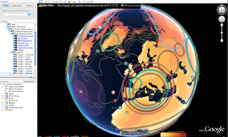
Think it's hot this summer? Wait until you see Google's simulation of a world with an average global temperature rise of 4C.
Using a map that was first launched by the former Labour administration in October 2009, the coalition government has taken temperature data from the Met Office Hadley Centre and other climate research centres and imposed it on to a Google Earth layer.
It's a timely arrival, with warnings this month that current international carbon pledges will lead to a rise of nearly 4C and the Muir Russell report censuring some climate scientists for not being more open with their data (but exonerating them of manipulating the scientific evidence).
more...
http://www.guardian.co.uk/environment/blog/2010/jul/14/google-climate-data
It's in the article link above, but here is the google link to the interactive map:
http://www.google.com/gadgets/directory?synd=earth&preview=on&cat=featured&url=http://maps.google.com/maps/gx?oe%3Dutf-8%26output%3Dghapi%26q%3Dhttp://www.fco.gov.uk/google-earth-4degrees.kml
You'll need download Google Earth 5 to view it.

2 comments:
Hmm. Unfortunately my computer and Google Earth 5 do not appear to be compatible, but I'm sure the view is staggering.
Sorry about that. It's quite impressive.
Post a Comment